| Japanese / English | |
HOME >> Nature Interface 2001.3: Special Features >> The Future of Whales
|
||||||||||
|
||||||||||
The Future of Whales TOMONAO HAYASHIProfessor, Chiba Institute of Technology 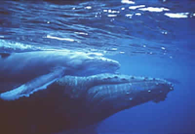
(1/3) next >>
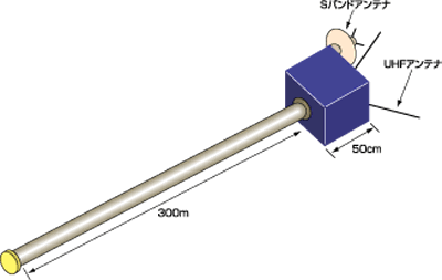
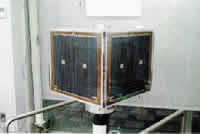
There are many opinions about the number of whales in the world. However, only a few things are known about the ecology of whales, which have a wide home range. Now, researchers are paying a great deal of attention to Professor Hayashi's project for the ecological investigation of whales using a small satellite. If this project is realized, we will be able to obtain data on the migration range of whales all over the world, and on their ecology in relationship to the ocean, besides being able to obtain other variable data about the ocean. The small satellite is planned to be launched, loaded by an H-II A Launch Vehicle, in February or March of 2002. The following is an interview with Prof. Hayashi, who proposed and worked hard on this project. Nature Interface (NI); Your research group made the WEOS (Whale Ecology Observation Satellite). In 1997, the WEOS was chosen as a small satellite for piggyback launch with NASDA's ADEOS-II (Advanced Earth Observing Satellite-II), by an H-II A Launch Vehicle Flight. Global-range investigation of whale ecology may be realized soon. Why did you think you wanted to investigate whales? Prof. Hayashi (H): We had launched several rockets every year to investigate atmosphere and the ionospheric layer. But the apparatus became complicated and expensive, so we decided to collect the rocket payload by separating it from the falling vehicle and dropping it onto the sea. We used the LORAN-C (Long-Range Navigation System-C) for the collection of the position data, since there wasn't a GPS (Global Positioning System) yet. I was also on the ship for collection of the payload. At that time, I wondered if we would be able to apply this technology to saving lives. My idea was this: send the information about the latitude and longitude from the buoy of the point where someone was shipwrecked to GMS (Geostational Meteorological Satellite: "Himawari"). Then, the information would be sent to a center for meteorological satellite communication at the Japan Meteorological Agency at Hatoyama Town, Saitama Prefecture. If there is a ship in the vicinity of the wrecked ship that can be sent to the site of the shipwreck, this would be the fastest way to effect a rescue. I proposed this idea at various places, but it's not realized yet. Later, I got the idea of using this system for whales. There are whaling and antiwhaling opinions, but the objective of our investigation is just to obtain scientific data. NI;How do you investigate whales? H: We investigate the position of whales using the GPS. As Fig. 1 shows, the WEOS (Whale Ecology Observation Satellite; Fig. 2) circles a polar orbit. Transmitters called probes are installed on whales, and data on the positions of the whales, the depth to which the whales dived, and the sea temperature at places where the whales are located, are stored in the probes's memories. Whales surface every several minutes for respiration, and the data stored in the probes are sent to the WEOS together with each identification code and recorded at that time. The control center at the Chiba Institute of Technology retrieves the data by sending a command signal to the WEOS each time the WEOS passes over the control center. Then researchers analyze the data, and learn about the ecology of whales. 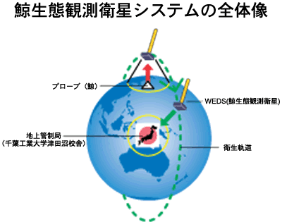
(1/3) next >> |
|Top of this Page|
©2000-2001 Nature Interface. corporation allrights reserved